Overview
This article provides a comprehensive comparison of GIS-integrated land records platforms for 2025, underscoring their pivotal role in enhancing property management through improved transparency, efficiency, and sustainability. It elaborates on key features such as:
- Real-time updates
- Data visualization
- Advanced search capabilities
Furthermore, a comparative analysis of leading platforms, including ArcGIS and QGIS, reveals their functionalities, costs, and integration capabilities, all of which are essential for informed decision-making in the real estate sector.
Introduction
GIS-integrated land records platforms are revolutionizing property information management by merging geographic data with real estate records. This integration enhances decision-making and operational efficiency, making these platforms essential for stakeholders, from government agencies to real estate professionals.
Furthermore, as these platforms evolve, they promise unprecedented transparency and sustainability in land management. However, with various solutions available, organizations face the challenge of determining which platform best meets their unique needs and maximizes their investment in this critical technology.
Overview of GIS-Integrated Land Records Platforms
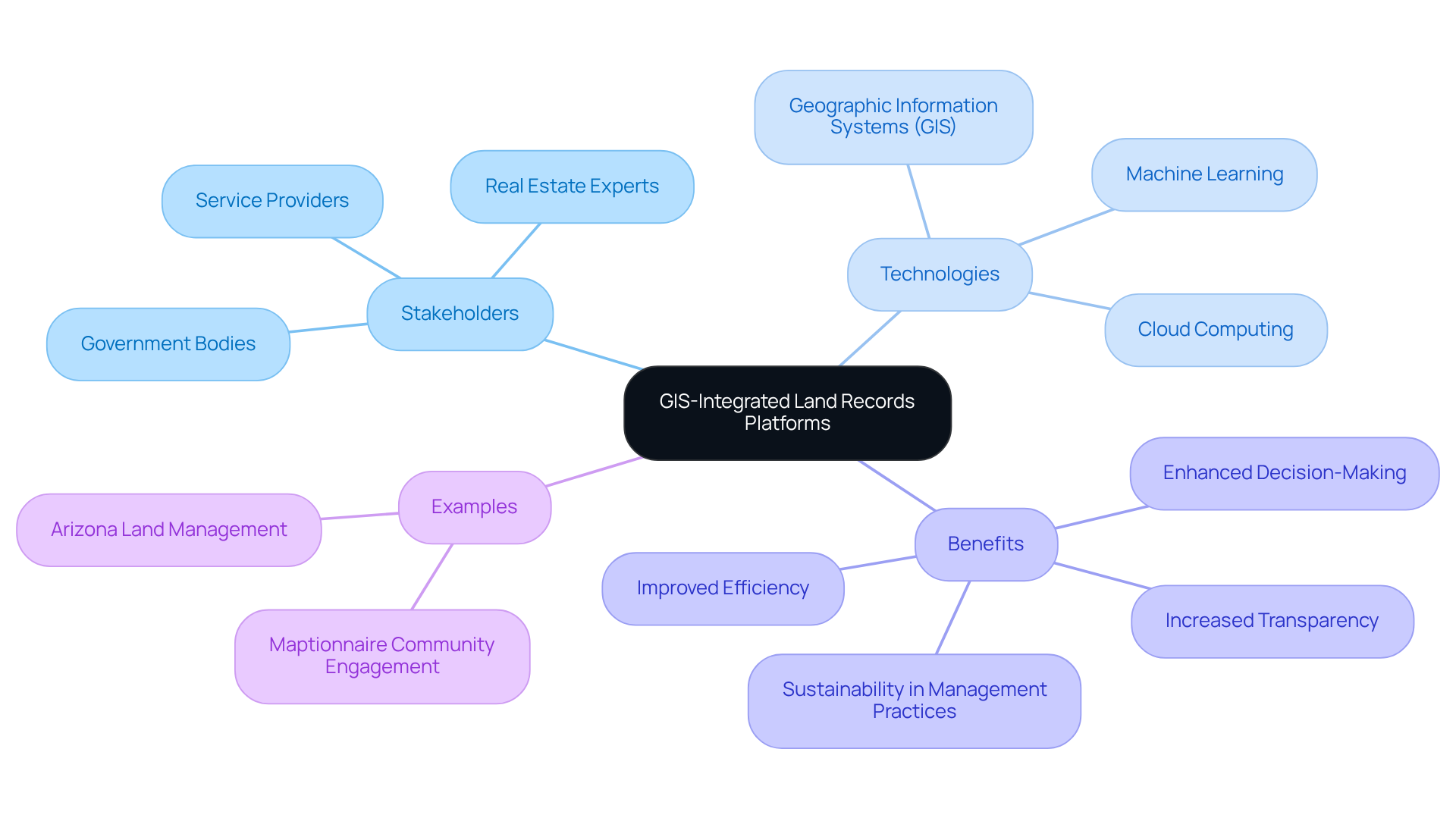
GIS-integrated land records platforms are essential for modernizing information management by merging geographic information with real estate records. The GIS-integrated land records platforms leverage to visualize, analyze, and manage terrain-related information, thereby significantly enhancing decision-making processes in property governance. In 2025, their importance is underscored by their capacity to promote transparency, efficiency, and sustainability in management practices.
Stakeholders—including government bodies, real estate experts, and service providers—gain from tools that provide precise mapping, real-time updates, and comprehensive data analysis. As the demand for efficient property management escalates, GIS-integrated land records platforms are evolving to incorporate advanced technologies such as machine learning and cloud computing, further enhancing their capabilities and user experience.
Successful implementations, such as those in Arizona, where GIS technology oversees over nine million acres, exemplify the efficiency gains achievable through GIS-integrated land records platforms, which include improved zoning and resource distribution. Furthermore, the integration of community input into planning processes, facilitated by platforms like Maptionnaire, highlights the critical role of public involvement in shaping resource management strategies.
As noted by Maptionnaire, 'GIS allows planners to merge various information sources effortlessly into one location-based system,' underscoring the importance of community engagement. Overall, the advancement of GIS technology in resource management is not solely about operational efficiency; it also promotes sustainable practices that address contemporary challenges.

Key Features of Leading Land Records Solutions
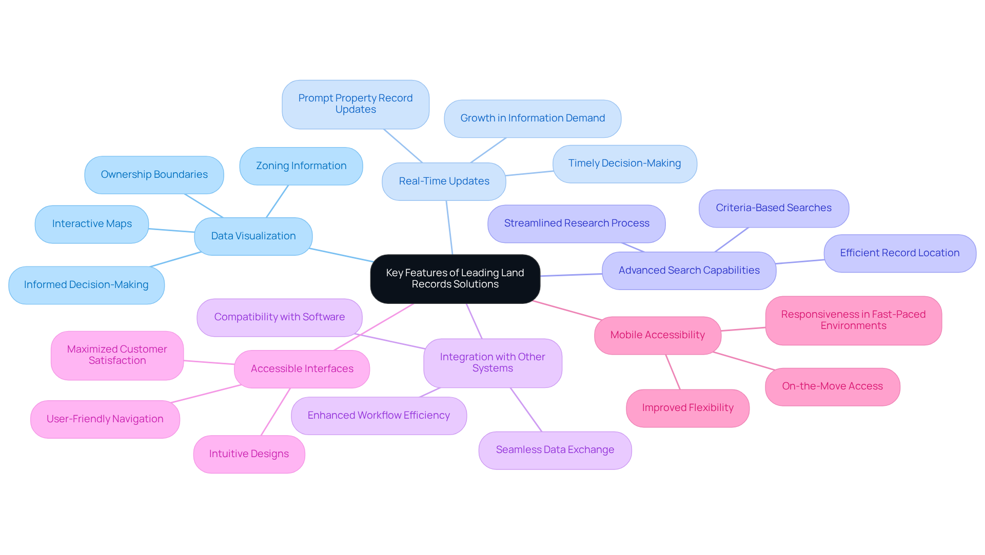
Leading gis-integrated land records platforms are increasingly focused on enhancing usability and functionality through several key features.
- Data Visualization: Interactive maps empower users to visualize land parcels, ownership boundaries, and zoning information, making complex data more accessible and understandable. As industry specialists emphasize, effective information visualization is essential for informed decision-making in resource management.
- Real-Time Updates: Contemporary systems guarantee prompt updates on property records, offering individuals the most up-to-date information and enabling timely decision-making. This capability is crucial, particularly given the 36% growth rate in demand for information specialists, highlighting the necessity for effective handling of information.
- Advanced Search Capabilities: Robust search tools enable individuals to efficiently locate land records based on various criteria, including location, ownership history, and property type, streamlining the research process. This feature is vital for enhancing productivity in title research.
- Integration with Other Systems: Compatibility with property management and financial software enhances workflow efficiency, allowing for seamless data exchange and collaboration across platforms. Such integration is increasingly recognized as a best practice in the industry.
- Accessible Interfaces: Intuitive designs accommodate both technical and non-technical individuals, ensuring that all stakeholders can navigate the system with ease. This emphasis on usability is crucial for maximizing customer satisfaction.
- Mobile Accessibility: Applications providing on-the-move access to property records improve flexibility and responsiveness, enabling individuals to remain informed irrespective of their location. This feature is particularly important in today’s fast-paced environment.
Together, these features enhance efficiency, precision, and client satisfaction in records management, particularly through the use of gis-integrated land records platforms, which showcase the latest trends in technology and expert perspectives on the significance of in the domain. For instance, the recent ArcGIS Pro 3.4 update has demonstrated significant performance improvements, showcasing the practical benefits of these advanced features.

Comparative Analysis of Top GIS-Integrated Platforms
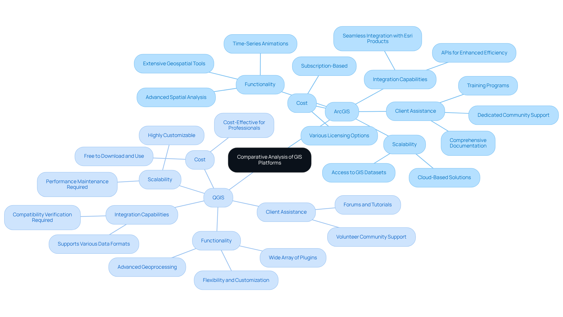
In evaluating the leading GIS-integrated land records platforms, several critical factors emerge:
- Functionality: Both ArcGIS and QGIS deliver powerful mapping and analytical capabilities. ArcGIS, developed by Esri, is recognized for its extensive geospatial tools and advanced spatial analysis features, making it suitable for complex projects. In contrast, QGIS, an open-source alternative, provides flexibility and customization through a wide array of plugins, serving various needs. For instance, the TimeManager plugin in QGIS enables individuals to animate vector features based on time attributes, enhancing temporal analysis. Furthermore, QGIS offers advanced geoprocessing capabilities through downloadable plugins, further showcasing its strengths compared to ArcGIS.
- Cost: The cost structures of these platforms differ significantly. ArcGIS typically operates on a subscription basis, which can be a barrier for smaller organizations or independent professionals. It offers various licensing options, including perpetual licenses and annual subscriptions, which can impact overall costs. Conversely, QGIS is free to download and utilize, making it an appealing choice for those mindful of expenses. This cost-effectiveness is particularly beneficial for real estate professionals who require robust GIS capabilities without the financial burden.
- Client Assistance: The availability of customer support and training resources can significantly influence customer experience. Esri offers comprehensive documentation, training programs, and a committed community, ensuring individuals can maximize their use of ArcGIS. On the other hand, QGIS benefits from a robust volunteer community that provides assistance through forums and tutorials, although it may lack the organized support available in commercial systems. Highlighting Esri's extensive resources can further enhance the comparison.
- Integration Capabilities: Effective integration with existing systems is essential for many organizations. ArcGIS excels in this area, offering seamless integration with other Esri products and APIs that enhance operational efficiency. QGIS also accommodates various data formats and standards, facilitating effective data exchange; however, users must verify compatibility when transitioning between platforms. Mentioning ArcGIS's integration capabilities provides a clearer picture of its advantages.
- Scalability: As organizations expand, their GIS needs may evolve. Platforms that provide cloud-based solutions, such as ArcGIS Online, offer scalability that can meet increasing demands from users. ArcGIS Online also grants access to a large number of GIS datasets, which can be advantageous for individuals as they broaden their GIS requirements. While QGIS is , it may require additional effort to maintain performance as project complexity increases.
This comparative analysis highlights the strengths and weaknesses of each system, guiding users in making informed decisions tailored to their specific needs in the real estate sector by utilizing GIS-integrated land records platforms.

Cost Analysis and ROI of GIS-Integrated Solutions
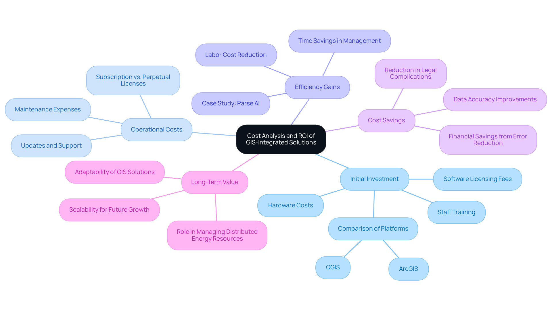
Assessing gis-integrated land records platforms necessitates a comprehensive cost analysis and ROI evaluation. Key considerations include:
- Initial Investment: This encompasses software licensing fees, hardware costs, and essential staff training. For instance, platforms like ArcGIS may require a higher upfront investment compared to open-source alternatives such as QGIS, which can be more budget-friendly.
- Operational Costs: Ongoing expenses, including maintenance, updates, and support, are critical to factor in. Subscription-based models often provide predictable costs, while perpetual licenses may incur additional fees for updates, impacting long-term budgeting.
- Efficiency Gains: Implementing GIS solutions can yield significant time savings in land records management, markedly reducing labor costs associated with manual processes. For example, Parse AI's machine learning capabilities can streamline title research, leading to faster turnaround times and improved workflow efficiency. As noted by Deloitte survey participants, 'The immense energy demand of information centers, often viewed as a challenge, can transform into an asset for the future grid,' underscoring the potential for GIS technology to enhance resource management.
- Cost Savings: Enhanced data accuracy and minimized errors can avert costly mistakes and legal complications, further boosting ROI. Organizations leveraging GIS technology frequently discover that the reduction in errors translates directly into financial savings. A case study on workforce development highlights that investing in technology can lead to significant operational improvements.
- Long-Term Value: The adaptability and scalability of GIS solutions can provide enduring financial benefits, establishing them as a strategic investment for organizations anticipating future growth and changes in operational needs. The integration of digital tools is expected to play a crucial role in , further emphasizing the importance of GIS in the evolving landscape.
In summary, a thorough cost analysis and ROI evaluation are essential for organizations to justify their investment in gis-integrated land records platforms, ensuring alignment with their financial and operational objectives.

Conclusion
GIS-integrated land records platforms are revolutionizing the management of property information, providing essential tools for transparency, efficiency, and sustainability in land governance. By merging geographic information systems with real estate records, these platforms enhance decision-making processes and facilitate superior resource management, rendering them invaluable for stakeholders across various sectors.
The article highlights key features of leading GIS-integrated platforms, including:
- Data visualization
- Real-time updates
- Advanced search capabilities
A comparative analysis between ArcGIS and QGIS showcases their unique strengths, such as ArcGIS's extensive geospatial tools and QGIS's cost-effectiveness. Furthermore, a thorough cost analysis and ROI evaluation underscore the long-term financial benefits of adopting these technologies, emphasizing their role in streamlining operations and reducing errors.
As the landscape of land management continues to evolve, embracing GIS-integrated solutions becomes increasingly crucial. Organizations are encouraged to consider the transformative potential of these platforms, not only for immediate efficiency gains but also for fostering sustainable practices and community engagement in resource management. The integration of advanced technologies in GIS will undoubtedly shape the future of land records management, making it imperative for decision-makers to stay informed and proactive in their adoption strategies.
Frequently Asked Questions
What are GIS-integrated land records platforms?
GIS-integrated land records platforms are systems that merge geographic information with real estate records to modernize information management, allowing for better visualization, analysis, and management of terrain-related information.
Why are GIS-integrated land records platforms important in 2025?
Their importance lies in promoting transparency, efficiency, and sustainability in management practices, which are crucial for effective property governance.
Who benefits from GIS-integrated land records platforms?
Stakeholders such as government bodies, real estate experts, and service providers benefit from these platforms through tools that provide precise mapping, real-time updates, and comprehensive data analysis.
What advanced technologies are being incorporated into GIS-integrated land records platforms?
Advanced technologies such as machine learning and cloud computing are being integrated to enhance the capabilities and user experience of GIS-integrated land records platforms.
Can you provide an example of a successful implementation of GIS-integrated land records platforms?
An example is Arizona, where GIS technology is used to oversee over nine million acres, leading to improved zoning and resource distribution.
How does community input factor into GIS-integrated land records platforms?
Platforms like Maptionnaire facilitate the integration of community input into planning processes, highlighting the importance of public involvement in shaping resource management strategies.
What is the overall impact of GIS technology on resource management?
The advancement of GIS technology in resource management not only improves operational efficiency but also promotes sustainable practices that address contemporary challenges.


